Tomorrow Starts Today
DMAGv350
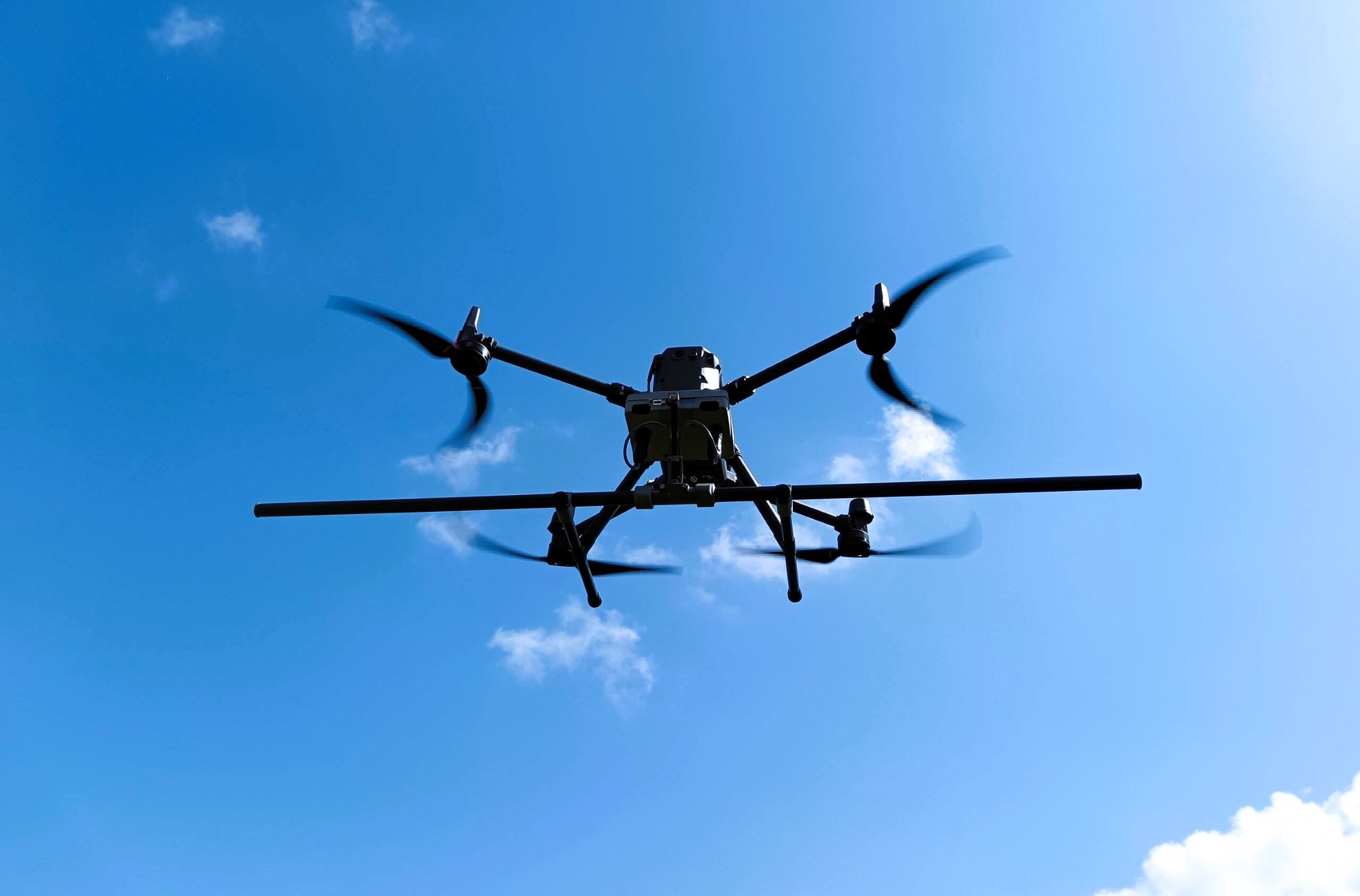
The DMAGv350 System is at the heart of the “A2dvance Near-Surface Detection System.” Specially developed for low-altitude total-field magnetic surveying, this system combines a UAV with custom-built sensor hardware and software.
It can autonomously fly survey grids at altitudes as low as 50 cm above the ground, ensuring precise data collection.
Applying to, but not limited to:
High-risk areas – unknown risks, IEDs, heavy contamination
Rugged terrains – swamps, steep slopes, wet meadows, deserts,
Nearshore areas - shallow water areas, beaches and tidal flats, salt swamps
Wide, open spaces like agricultural areas, deserts, scree fields and military training grounds
Nature conservation areas - that may not be entered.
Several geophysical technologies can detect ERW. Most of these technologies rely on the magnetic or electromagnetic properties of the ordnance for detection. Many types of ordnance have magnetic and electromagnetic characteristics that differ from those of the surrounding soil. With the appropriate equipment for data recording and evaluation, it is possible to identify ordnance as anomalies or interfering objects compared to the background.
Magnetic field anomalies are caused by magnetized objects located beneath the surface. A magnetic interference field, also known as an anomaly, is defined as a deviation in the measured values from the normal magnetic field, which essentially behaves like a dipole field.
To detect explosive ordnance using drones, SeaTerra Technologies (STT) employs Total Magnetic Intensity (TMI) geophysical technology, which has been approved and proven effective. TMI measures the total intensity of Earth's magnetic field to provide accurate information about metallic anomalies at various depths. STT uses "fluxgate" magnetometers to apply this geophysical method.
The DMAGv350 roots were in size at the end of 2016 when the idea of a drone magnetometer was born in the Seaterra. The initial goal was to develop a tool to survey “transition” areas in the North and Baltic Seas. Up to the development of the DMAG, that was an almost impossible task. After years of testing and trial, the DMAGv210 was born in 2018.
For this purpose, SeaTerre, jointly with AGS – Advanced Geophysical Systems, run by Steven Lee, developed flight software, data analysis and hardware. This system was the first unmanaged UAV magnetometer system in the world, and it's still operational on the day-by-day tasks.
With time, a lot of experiences were gathered, and technology was developing so fast that DMAG systems needed to have in-depth modernizations. All the feedback from the fields and endless trials was incorporated into the new DMAGv350
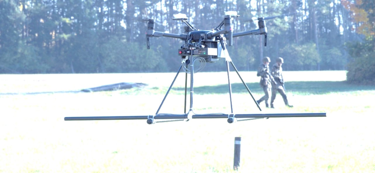
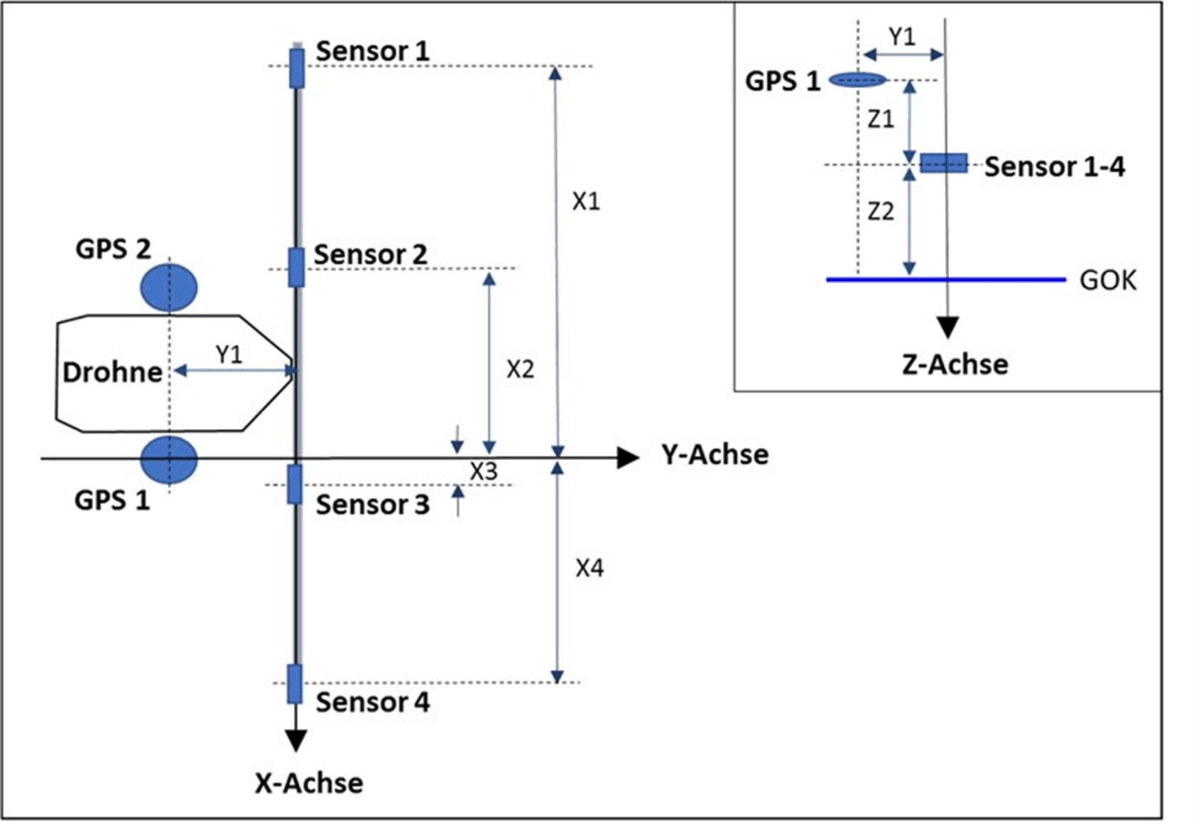
The UAV (DJI 350) was fitted with four 3-axis fluxgate magnetometers and two GPS antennas, which enabled data recording across a wide area with a track width of 2 meters. The dual GPS facilitated the capture of position and direction data, which was continuously recorded and displayed in real-time on the remote control display. Disturbances caused by flight movements and rotor currents are compensated during data acquisition, which was one of the main challenges.
The DMAG positioning system utilises GPS antennas on both the UAV and separate base stations. The system can use dual GPS on the UAV to record position and direction data during measurements. DMAG typically utilises RTK (kinematic real-time) with a base station to control the drone and ensure absolute real-time positioning. A base station is set up at a reference point to provide GPS correction values to the drone.
Fluxgate magnetometers measure the Earth's magnetic field in three dimensions. To ensure precise readings, these magnetometers undergo calibration before any measurements are taken. When a UAV is used for data collection, it rotates around the three axes of the sensors at an altitude of approximately 30 meters. To eliminate external interference, the magnetic data is corrected using specialized correction matrices that reduce the electromagnetic effects caused by the drone.
A calibration flight is conducted prior to each measurement session to determine the necessary compensation parameters. The in-house software AGSProc calculates these parameters based on a scalar approximation of the total magnetic field. Calibration is a critical step in collecting accurate field data, and solving this challenge was one of the key tasks addressed by the R&D team.
The drone utilizes four 3-axis fluxgate magnetometers to probe the target areas. Before the measurement process begins, the flight path is designed to ensure complete coverage of the area by parallel trajectories, enabling the detection of magnetic anomalies from potential interfering bodies. The magnetometer and positioning systems process position and sensor data in real time. For this purpose, SeaTerra employs AGSDrone, custom software developed specifically for explosive ordnance detection.
During measurements, the four sensors are rigidly mounted below the drone, with the sensor array axis aligned parallel to the terrain surface. The precise arrangement of the two GPS antennas and sensor positions defines a fixed geometry stored in each measurement file within the evaluation software, ensuring accurate data processing and interpretation.
All sensor and positioning data converge within the data recording software, continuously storing raw, unprocessed data. Real-time processing integrates sensor data with calculated position information, including altitude, flight height, directional data, movement tracking, and the positions of both the drone and the measurement platform. This data is graphically displayed based on the established system geometry. The integration of position and sensor data enables precise survey control and navigation during measurements. These parameters are essential for accurate data processing and interpretation, and all exploratory information is monitored and displayed in real-time, providing continuous oversight of the survey's progress.
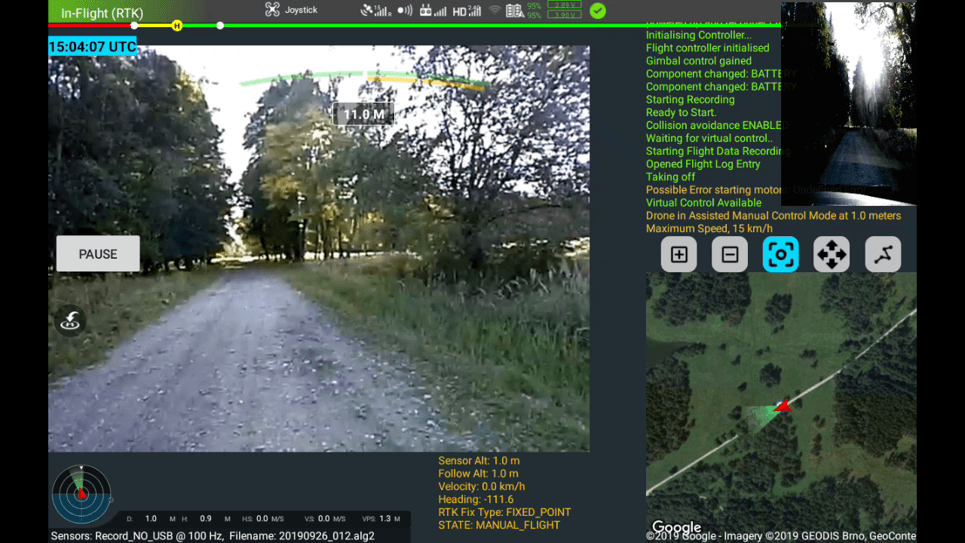
Navigation during the measurement is carried out through the use and presentation of the navigation software "AGSDrone". Manual control is also possible if the measuring field previously defined by a DXF overlay cannot be flown autonomously due to obstacles (e.g. trees) and the resulting interrupted satellite signals. The altitude above ground, the line spacing, the sampling rate, and the airspeed are freely selectable parameters.
At the same time as the sounding, all position data is displayed on the UAV pilot's external monitor. This real-time control of all parameters allows prompt correction of measurement gaps and/or track deviations.
We had the valuable opportunity to conduct long-term, parallel testing of the old DMAGv210 and the new DMAGv350. This side-by-side comparison provided us with clear insights into the progress made in developing these systems.
From a user experience perspective, the most noticeable difference is the integration of the more advanced UAV (Matrice 350), which offers enhanced comfort and improved performance for operators. While we won’t delve into the specifics of the Matrice 350, the differences are significant and contribute to a much smoother operational experience.
Regarding the sensor bar, it’s evident that the DMAGv350 is now a final product that has been thoroughly tested and verified. At the heart of both systems are the renowned Bearton sensors, some of the best on the market, ensuring optimal system performance. The DMAG box, designed specifically by SeaTerra Technologies, is now more reliable and rugged than its predecessor, improving overall system robustness.
For operators, the crucial component is the specially developed AGS software suite AGS Pilot and AGSDrone—these software solutions round out the system, providing excellent results in the field. AGS Pilot offers key features, such as stable automatic flight at 50 cm above the ground, which is essential for gathering quality data. The user interface has also been streamlined, with key information readily available without interrupting the operator’s workflow—though additional details are just a click away when needed.
AGSDrone, explicitly developed for the "A2 Advanced Near-Surface Detection System" based on AGSProc, is pivotal in ensuring seamless integration of sensor data and operational control. This marks a significant breakthrough in the DMAGv350 system.
With a cross-section of field data dating back to 2018, STT has introduced its new "recipes" approach—an innovative development that sets the DMAGv350 apart. As more global data is collected, we are confident that STT's "cookbook" will continue to evolve, offering refined solutions and further improvements.
SeaTerra Technologies GmbH, building on the experience of its sister company Seaterra GmbH Geophysics & EOD Services, continues to push the boundaries of innovation in geophysics, ordnance probing, marine operations, and remote sensing. Their commitment to precision and technological advancement has delivered excellent results, and we look forward to the continued evolution of these systems in the field. We were present for an endless discussion of how to improve and streamline customer support. Time will tell if the STT crew succeeds in that.